Drone LiDAR vs. 3D Photogrammetry: Choosing the Right Drone Mapping Solution in North Texas
As drone surveying rapidly expands across North Texas, businesses, engineers, and developers are increasingly choosing between two advanced aerial mapping technologies: Drone LiDAR and 3D Photogrammetry.
Whether you’re planning a construction project in Celina, managing land development near Frisco, or surveying infrastructure across the Dallas–Fort Worth Metroplex, selecting the right technology directly impacts accuracy, cost, and project timelines.
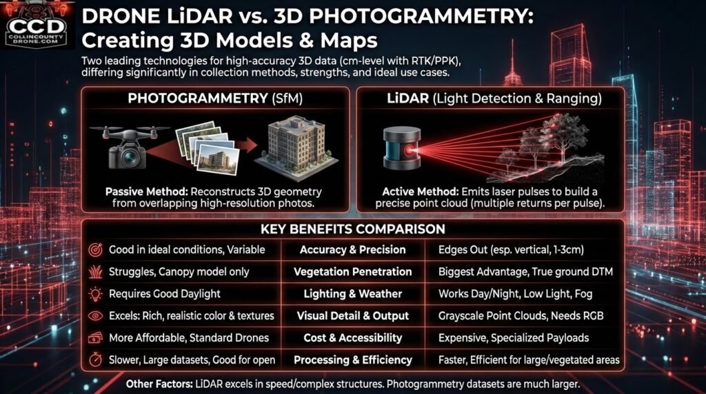
Both solutions can achieve survey-grade, centimeter-level accuracy using RTK/PPK drone systems — but each excels in very different environments.
Understanding Drone Photogrammetry (Best for Construction & Visual Mapping)
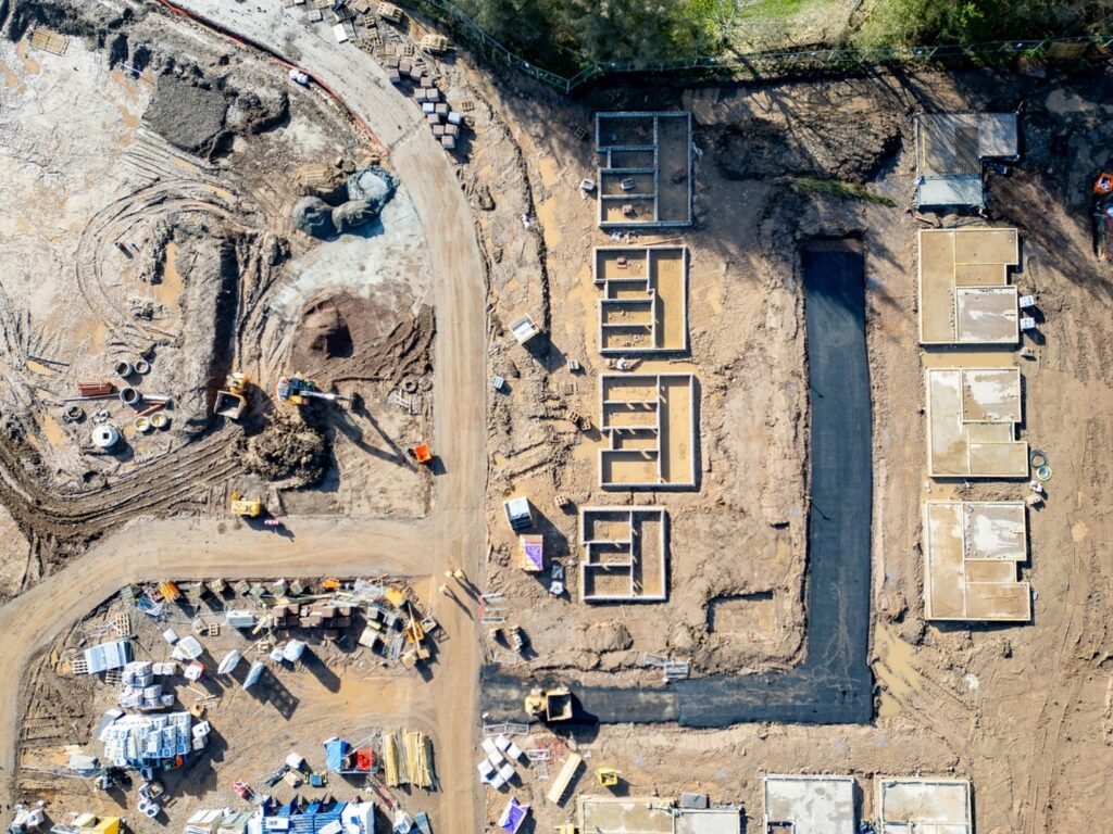
Photogrammetry uses high-resolution drone imagery to create accurate 3D models and maps. A drone captures hundreds of overlapping photos, and specialized software reconstructs terrain and structures using shared reference points.
Why North Texas Projects Often Choose Photogrammetry
Photogrammetry performs exceptionally well across the open landscapes common throughout fast-growing areas of Dallas suburbs and new development corridors.
Ideal for:
- Construction progress tracking
- Residential and commercial development
- Stockpile and earthwork volume calculations
- Real estate marketing visuals
- Site inspections and documentation
Local Advantage
For large, cleared construction sites typical in expanding North Texas communities, photogrammetry delivers high-resolution visual data at a lower operational cost.
Understanding Drone LiDAR (Best for Terrain & Vegetation Mapping)
LiDAR (Light Detection and Ranging) is an active laser-based sensing technology. Instead of relying on sunlight, the sensor emits laser pulses and measures their return time to build an ultra-precise 3D point cloud.
Unlike cameras, LiDAR can penetrate gaps in vegetation — a major advantage for rural and semi-wooded properties common across Texas.
When LiDAR Is the Better Choice
- Acreage and land development surveys
- Floodplain and drainage analysis
- Forestry and environmental studies
- Utility corridor and power line inspections
- Sites with heavy brush or tree canopy
Local Advantage
Many undeveloped North Texas parcels contain grasslands, tree clusters, or uneven terrain where traditional imagery cannot accurately capture ground elevation.
Drone LiDAR vs. Photogrammetry: Quick Comparison
|
Feature |
Drone LiDAR |
3D Photogrammetry |
|
Terrain Accuracy |
Excellent vertical precision |
High in open areas |
|
Vegetation |
Maps ground beneath trees |
Captures surface only |
|
Visual Quality |
Engineering-focused data |
Photorealistic models |
|
Lighting Conditions |
Day or night operation |
Requires daylight |
|
Project Cost |
Higher equipment investment |
More budget-friendly |
|
Processing |
Faster terrain extraction |
Image-heavy processing |
Which Drone Mapping Method Is Best for Your North Texas Project?
Choose Drone LiDAR If You Need:
 Accurate terrain under vegetation Pre-development land surveys Utility or corridor mapping Engineering-grade elevation models
Choose Photogrammetry If You Need:
Construction progress reporting High-resolution visual models Volume measurements and grading verification Cost-effective aerial mapping
Why Local Conditions Matter in Drone Surveying
North Texas presents unique surveying challenges:
- Rapid suburban expansion
- Mixed rural and urban terrain
- Seasonal vegetation growth
- Large-scale land development
Because of this, experienced drone operators often recommend photogrammetry for active construction sites and LiDAR for raw land or environmental analysis.
Choosing correctly reduces rework, speeds approvals, and improves planning accuracy.
Final Thoughts: The Right Eye in the Texas Sky
Drone LiDAR and photogrammetry are not competing technologies — they are specialized tools designed for different project goals.
For developers, engineers, and property owners across North Texas, selecting the right aerial mapping solution means:
- More reliable data
- Faster deliverables
- Lower long-term costs
- Better project decisions
When matched to the environment, drone surveying becomes one of the most powerful tools available for modern land development.